Historic American maps show how the country developed
Mapping America
As well as depicting the world we know today, maps offer a unique way of bringing history to life. Nowhere is this truer than America, which changed beyond recognition over a relatively short period of time. From the days of 'the New World' through turbulent wars that shaped American identity – it’s all been captured by cartographers over the centuries.
Click through this gallery to discover historic maps showing the remarkable development of America…
Discovering the New World
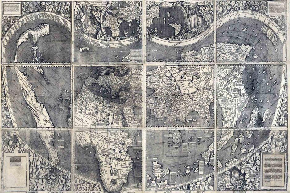
The landmark Waldseemüller Map of 1507 (pictured) was the work of Germans Matthias Ringmann and Martin Waldseemüller. The pair combined known history with reports from various recent explorations to depict the world as they knew it.
Previously, Europeans believed the world had just three areas – Asia, Africa, and Europe. The Waldseemüller Map, and the accompanying book, created a year after Christopher Columbus's death, recognized a fourth (the strip on the left). It was named 'America' after the Italian explorer Amerigo Vespucci.
European explorers
Through the 1500s and 1600s, North America saw the arrival of European explorers, mostly from France, Spain, and Britain. The first permanent European settlement in what is now the United States was St Augustine in Florida, founded by the Spanish in 1565.
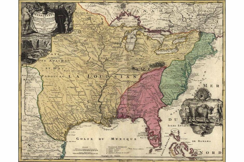
During the 17th century, French explorers like Marquette and Jolliet, Robert de La Salle, and Louis Hennepin claimed a large portion of North America, naming one region 'La Louisiane' (Louisiana) for King Louis XIV of France. This map shows American territorial claims by these explorers in 1687: yellow for France, red for Spain, and green for Britain.
Sponsored Content
British colonization
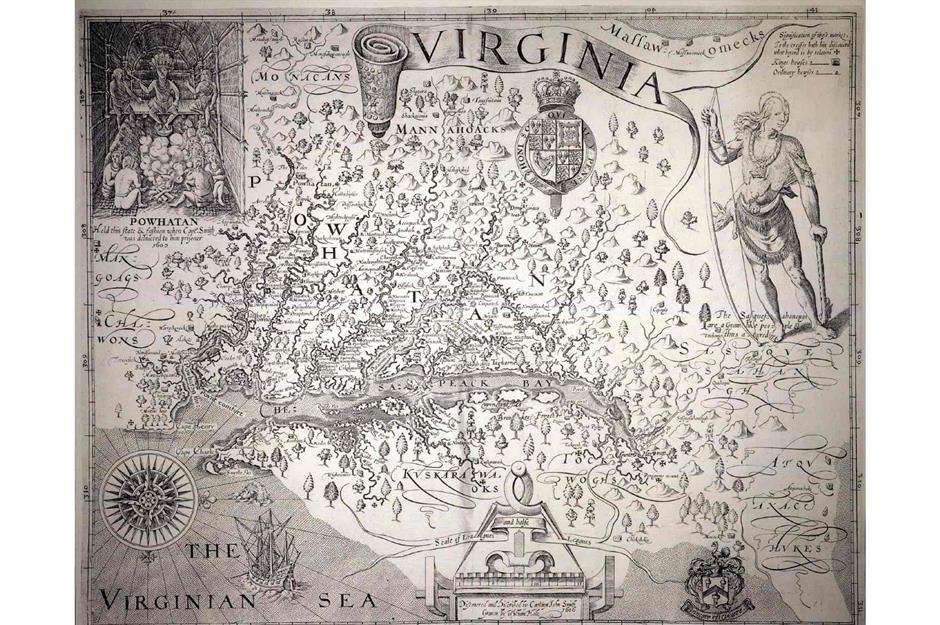
British colonization centered on America’s east coast. After earlier failed attempts, a permanent colony was established in 1607 at Jamestown, Virginia on Chesapeake Bay. Pictured here is Captain John Smith's map of Virginia, which was published in 1612.
In 1620, the Mayflower transported around 100 pilgrims fleeing religious persecution in England to the New World, where they established the Plymouth Colony by Cape Cod. This period marked the start of the 13 original colonies, which would stretch from New England down to Georgia.
The French and Indian War
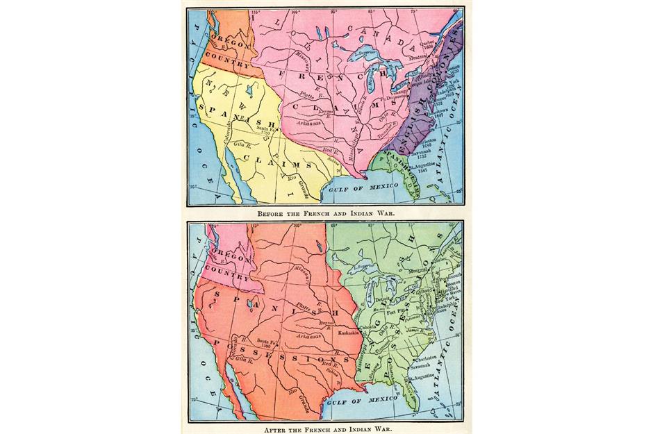
The French and Indian War (1754-63) was the North American theater of a broader conflict called the Seven Years’ War, and saw thick fighting between Britain and France. The British were victorious and made territorial gains (this map shows North America before and after the war), while France ceded its Louisiana colony to Spain. The conflict paved the way for the American War of Independence, as the escalating costs prompted Britain to call in taxes on its American colonies, leading to dissent.
Love this? Follow us on Facebook for more travel and history content
The American Revolution
.jpg)
These unpopular taxes began almost as soon as the French and Indian War finished. The imposition of the Stamp Act in 1765 stoked tensions between Britain and the 13 colonies, and it was repealed within a few months after fervent protest. The Townshend Acts of 1767, which were supposed to force the colonists to comply, damaged the relationship further.
The Revolutionary War broke out in 1775 and lasted until 1783. On July 4, 1776, Congress adopted the Declaration of Independence – making the colonies free and independent states. This map depicts the 13 colonies as of 1776.
Sponsored Content
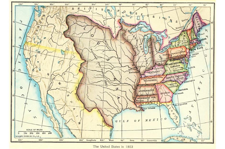
The Louisiana Purchase

America’s map changed again in 1803 with the Louisiana Purchase, which saw the new nation buy 828,000 square miles of land from France for the price of $15 million, effectively doubling the country’s size. Considered one of America’s most important land acquisitions, the purchase opened the door to westward expansion.
France had regained control of these lands from Spain in 1800, and in 1804 an expedition led by Meriwether Lewis and William Clark set out to explore them. This map reveals the extent of the purchase, covering parts of 15 future US states.
The Missouri Compromise
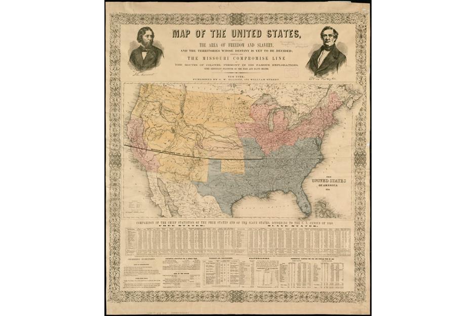
By 1820, the US had 23 states, and tension was growing between the states that allowed slavery and the states that did not. In 1821, Missouri was added as a 'slave state' amid much controversy, shortly after Maine had been admitted as a 'free state.'
The Missouri Compromise aimed to maintain a balance in the US Senate and drew a line east-west along the 36th parallel, dividing the nation into competing halves with competing ideas about slavery. The compromise was repealed by the 1854 Kansas-Nebraska Act and declared unconstitutional by the Supreme Court in 1857.
Westward expansion
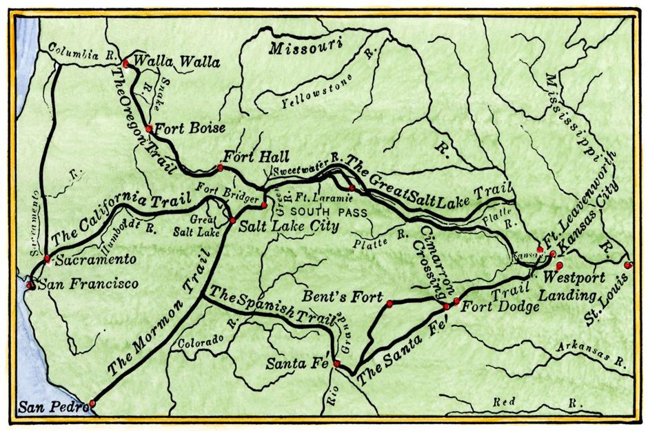
America’s westward expansion gathered pace through the early 19th century. A phrase used to describe this historic process was 'manifest destiny' – a belief that the country was destined to expand its borders, regardless of the impact on the Indigenous peoples they encountered.
Key routes created at this time included the Oregon Trail, the Mormon Trail, and the Santa Fe Trail. These routes were widely used for commerce or by pioneers seeking a better life. This map highlights just a few of them.
Sponsored Content
Native American lands
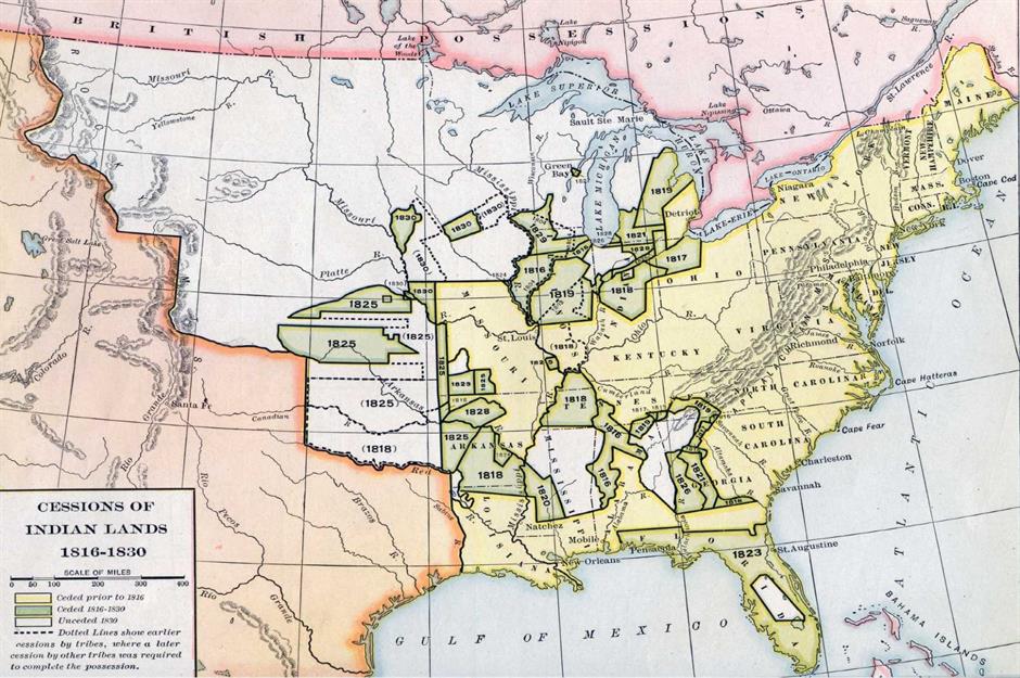
The arrival of European settlers had an enormous impact on North America's Indigenous people, and this only worsened as America expanded westward. Between 1500 and 1900, the Native American population fell from between one and 18 million (estimates vary wildly) to 270,000.
This map indicates ceded Indigenous land between 1816 and 1830, the year of the Indian Removal Act. This act saw the forced and often fatal relocation of around 60,000 Native Americans from their lands to what is now Oklahoma – known today as the Trail of Tears.
The Mexican-American War
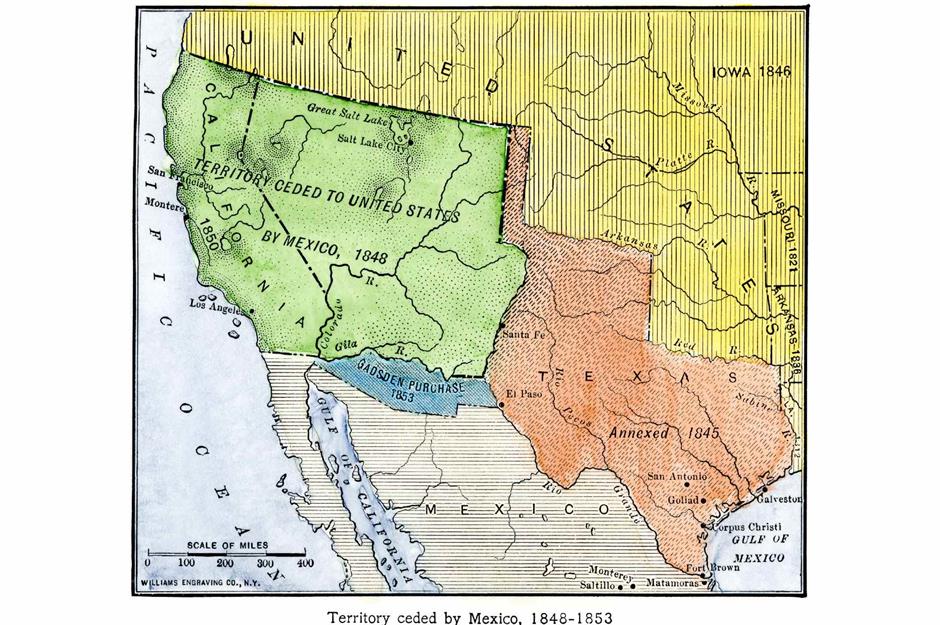
Another major factor in westward expansion was the territory acquired following the Mexican-American War (1846-48). The conflict was sparked in 1845, when Texas was annexed into the United States and admitted as the 28th state, leading to a border dispute with Mexico.
The war ended with the signing of the Treaty of Guadalupe Hidalgo. This saw the United States gain the entire states of California, Nevada, and Utah, plus parts of New Mexico, Arizona, Colorado, Oklahoma, Kansas, and Wyoming. This map shows the extent of the gains (in green), as well as areas of Arizona and New Mexico gained via the 1854 Gadsden Purchase (in blue).
The Compromise of 1850
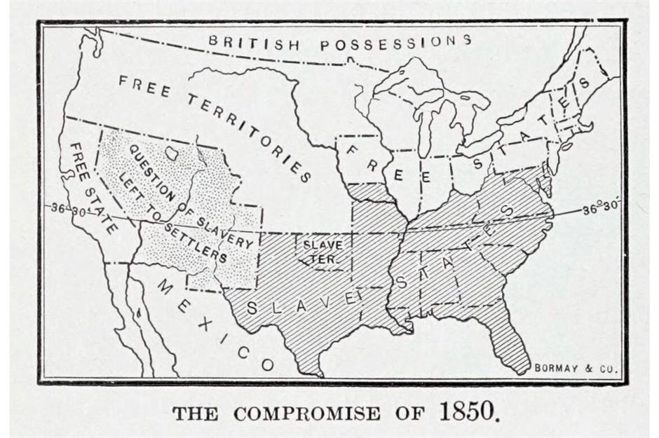
In 1850, the US comprised 31 states. With the Union growing all the time, tensions between free and slave states continued. One controversial solution to this tension was the Compromise of 1850.
This was a package of five laws which, among other things, formally admitted California as a free state. The map shows the practical outcome of the Compromise of 1850. By partly pacifying both sides, the laws worked to hold off the Civil War, if only temporarily.
Sponsored Content
Underground routes
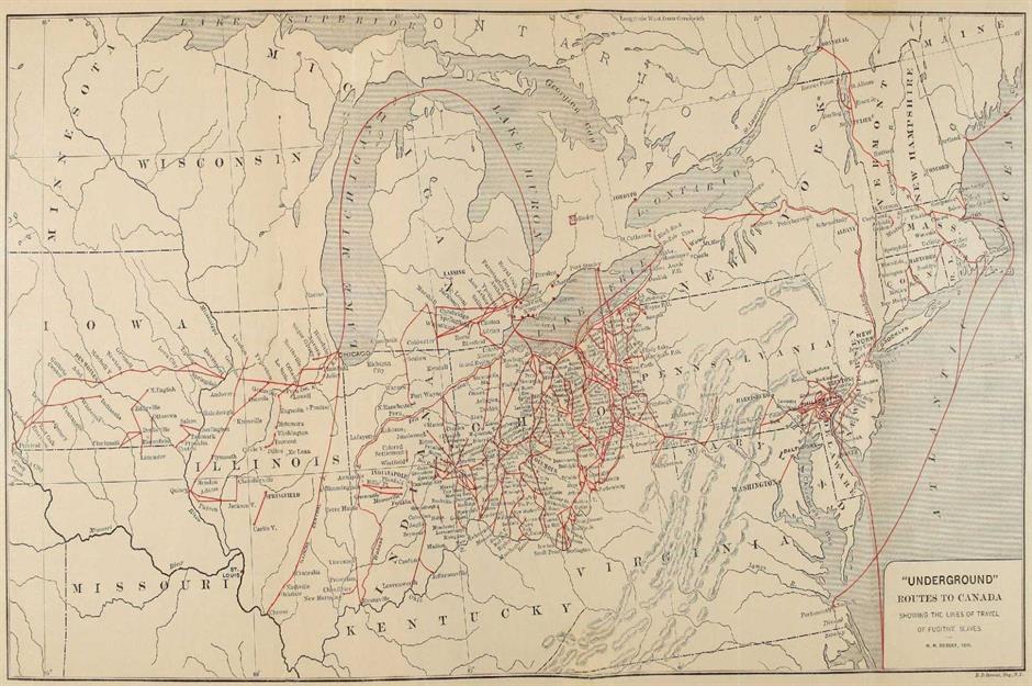
The Compromise of 1850 also introduced the second Fugitive Slave Act, which made aiding runaway slaves a crime. In response, abolitionists strengthened and expanded a network of secret routes known as the Underground Railroad, with safe houses along the way.
Estimates suggest that between 40,000 and 100,000 fugitive slaves and free African Americans from the South escaped to the northern US and Canada, as well as to larger cities like Atlanta and Richmond. This map shows a section of these vital underground routes.
The American Civil War
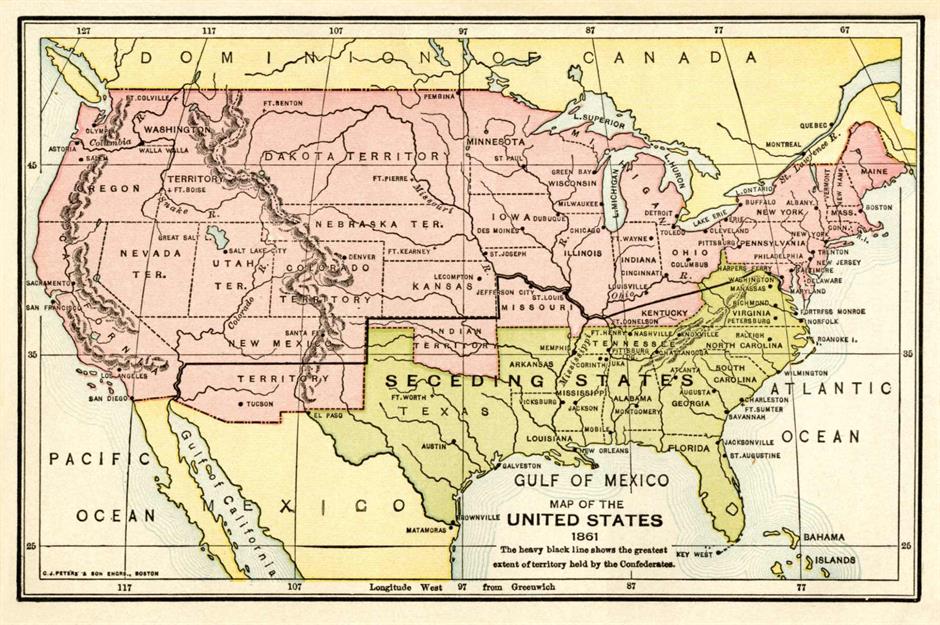
The Civil War (1861-65) was fought between the Union and the Confederacy – respectively the free states in the North and the slave states in the South. The South comprised 11 states that wanted to secede from the United States, and from its president Abraham Lincoln.
The war began when Confederate forces attacked Fort Sumter in South Carolina, and ended with the surrender of Confederate General Robert E Lee at Appomattox Court House in Virginia. The North’s victory preserved the Union and led to the abolition of slavery.
The rise of the railroads
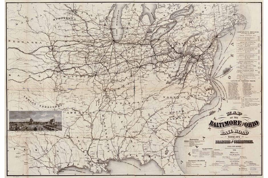
The advent of the railroads turbocharged westward expansion and industrialization. In 1869, the 1,912-mile Transcontinental Railroad opened, cutting travel times between the east and west coasts from months to a single week. It took six years to build (mostly by hand).
Pictured here is a map from 1878 of the Baltimore & Ohio, America’s oldest steam railway carrying freight and passengers. Construction of the line began, fittingly, on July 4, 1828, and it helped to transport supplies during the Civil War.
Sponsored Content
An immigration nation
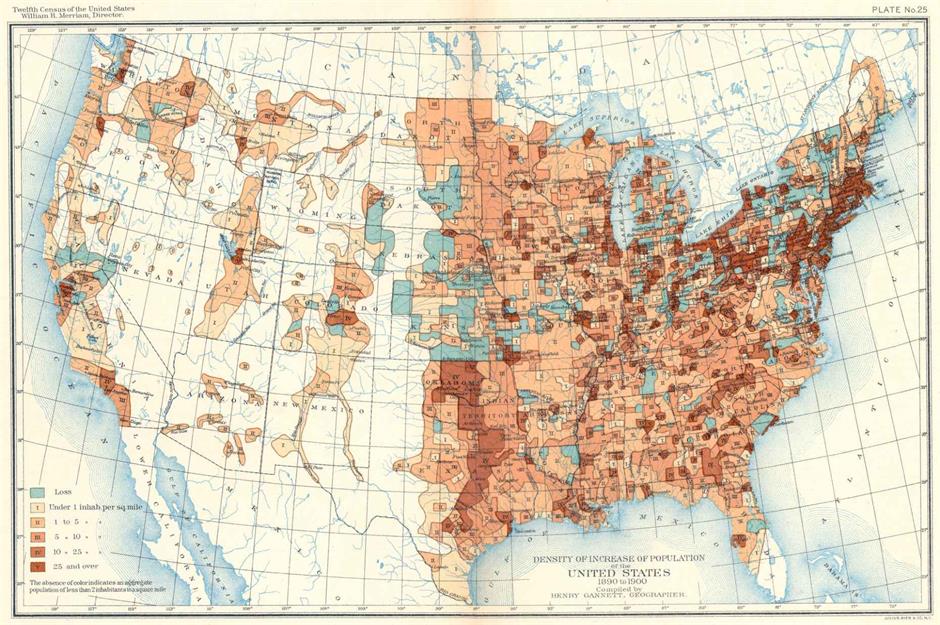
The late-19th century brought a large wave of immigrants to America, with millions arriving from countries like Italy, Poland, Russia, and Lithuania. The opening of New York’s Ellis Island as an immigration station in 1892 made it the primary arrival point for those seeking opportunity across the sea.
This map highlights increases in US population density from 1890 to 1900. The largest rises in those years (in red) are around the major northeastern cities, as well as in Texas and a few key hubs in the west.
World War II
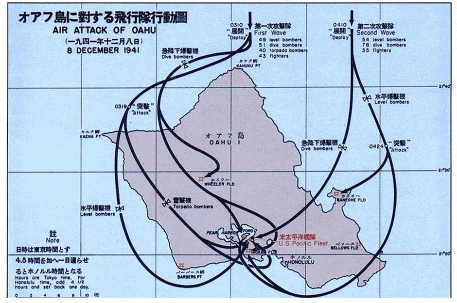
America entered World War I on the side of the Allies in 1917, but then passed a series of Neutrality Acts in the 1930s aimed at staying out of further European conflicts. America only entered World War II following Japan’s surprise attack on the US naval base at Pearl Harbor in Hawaii on December 7, 1941, a date President Franklin D Roosevelt said would "live in infamy." This image shows Japan's bombing map (the date, December 8, reflects the 19-hour time difference).
Cold War America
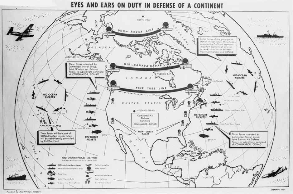
Following the end of World War II, America became embroiled in decades-long geopolitical tensions with the Soviet Union. The Cold War even brought the world to the brink of full-blown nuclear war before coming to a close in 1991. This 1956 map shows the lines of radar stations that aimed to give America advance warning of enemy attack, especially the Distant Early Warning (DEW) Line, which stretched 3,000 miles from northwest Alaska to Iceland.
Sponsored Content
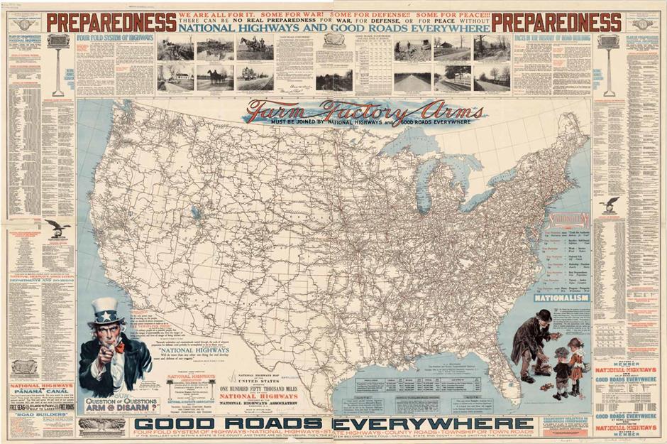
The Interstate Highway System
Despite Cold War tensions, post-war America boomed, with a thriving economy and an expanding suburban middle class. For many, it was the era of the American dream, and amid all the other developments the passing of the Federal-Aid Highway Act of 1956 sparked a vast road-building project – the Interstate Highway System that now stretches nearly 47,000 miles. The National Highways map pictured here shows the extent of the country’s interstate routes and roads.